HOME RESEARCH INTERESTS PUBLICATIONS TEACHING PEOPLE OPEN POSITONS

Research Interests

Our primary research objective aims to better characterize constituents of terrestrial ecosystems and improve our understanding of the coupled water and carbon cycle utilizing high resolution remote sensing observations.
Specifically, we are interested in quantitative esimation of soil attributes and vegetation structure and function in terrestrial ecosystems using imaging spectroscopy and LiDAR (Light Detection and Ranging) observations from airborne, ground based as well as satellite based platforms. These observations and characterizations of terrestrial ecosystems are extremely valuable for quantifying water and carbon fluxes as well as their variability under various environmental stresses utlizing newer biophysical process based models incorporating the soil plant atmosphere continuum. Some details on past and present projects involving these research objectives are presented below.

Present Research Areas:

Quantitative Characterization of Surface Soil Attributes using Imaging Spectroscopy (top)

Soil textural attributes (% sand, silt, clay) on the landscape are important for hydrological modeling. Soil organic matter together with macro and micro nutrients are extremely important for assessing the soil health and plant productivity. We have demonstrated that it is possible to quantify these soil attributes at very high spatial resolutions using airborne imaging spectroscopy having high signal to noise ratio of the sensor. We further demonstrate that the methodology based on statistical learning frameworks may be applicable for a range of constituents with limited gound samples and potentially be applicable from space based hyperspectral observations.


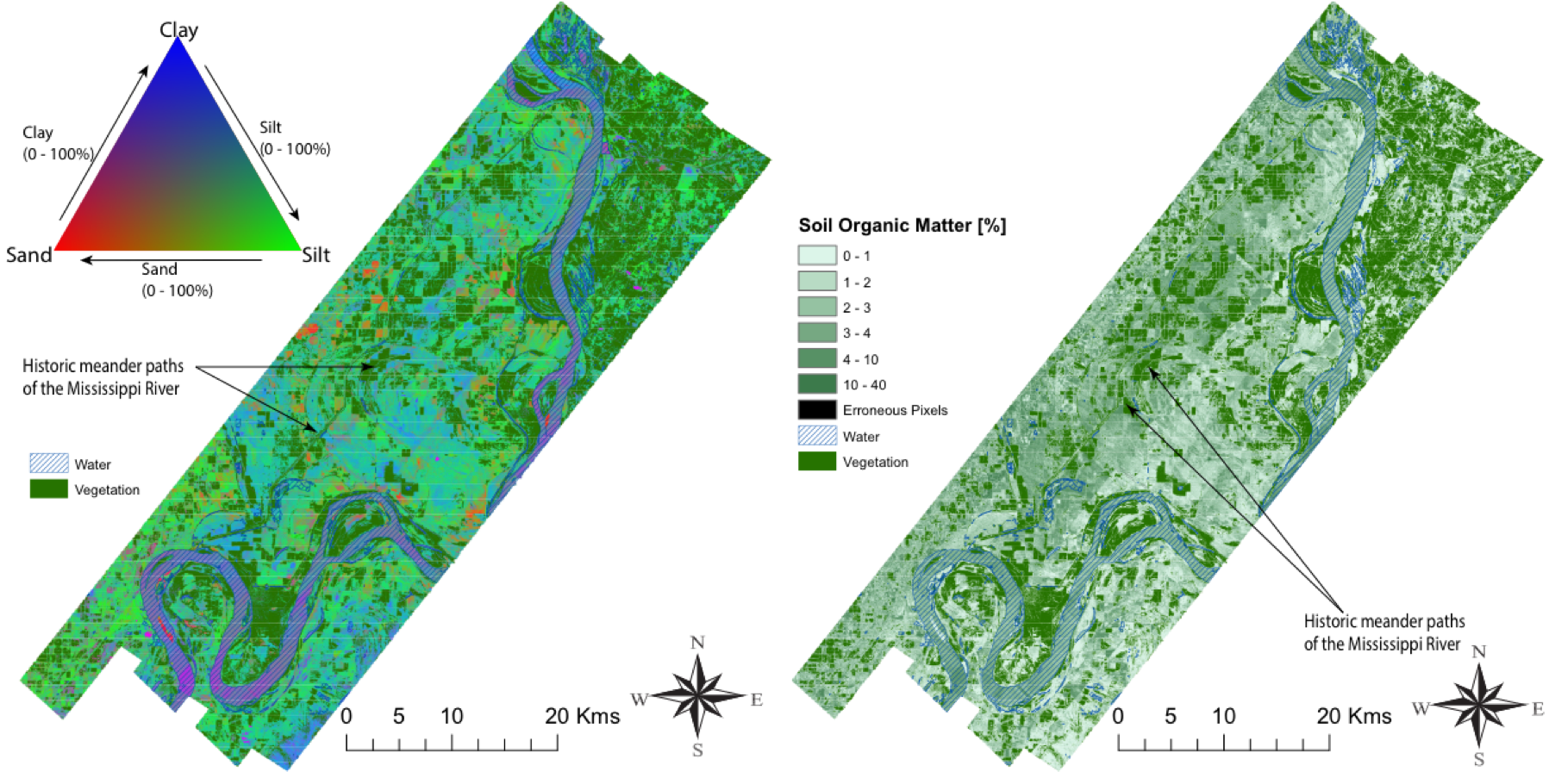
Fig. High-resolution spatial prediction map of soil texture shown as tricolor RGB composite for percentages of sand, silt, and clay (left) and soil organic matter content (right) for Bird’s Point New Madrid Floodway. Large-scale legacy landscape features of the Mississippi River are clearly observable.
Reference(s):
  • Dutta et al. (2015), On the Feasibility of Characterizing Soil Properties From AVIRIS Data, IEEE, Transactions on Geoscience and Remote Sensing
  • Dutta et al. (2017), Effects of Spatial Filtering for Characterizing Soil Properties from Imaging Spectrometer Data, IEEE, JSTARS


  • Characterizing Vegetation Canopy Structure using Airborne Remote Sensing (top)

    The vegetation canopy structure is extremely important for determining the vertical distribution of radiative states and scalar fluxes. This is crucial for photosynthesis and transpiration. Active optical remote sensing such as LiDAR and specifically point cloud LiDAR data is beneficial for estimating the vertical foliage distribution. Low density of point clouds poses a challenge for characterization in dense overlapping forest canopies. Fusion of imaging spectroscopy and point cloud lidar in a feature based approach may be a better approach in such scenarios.


    Fig. Tree crown delineation and tree species identification using airborne LiDAR and hyperspectral data (left). Individual canopy leaf area density estimation using novel voxelization approach using feature based data fusion.
    Reference:
  • Dutta et al. (2017), Characterizing Vegetation Canopy Structure Using Airborne Remote Sensing Data, IEEE, Transactions on Geoscience and Remote Sensing


  • Temporal Dynamics of Coupled Water and Carbon Cycle (top)

    Currently process based models representing the soil plant atmosphere continuum are equipped to take advantage of the high resolution remote sensing measurements in predicting dynamics of water and carbon fluxes from ecosystems. These models have the detailed mechanistic process representation at various scales in order to better understand functioning of ecosystems. Assimilating high resolution observations into these models using inversion frameworks helps to quantify the ecosystem response under various environmental stresses as well as improve underlying model structural formulation.


    Fig. Illustration of moving window inversion retrieval setup. The bottom left part illustrates the annual ecosystem time series flux variables used for driving the model. The top right shows the vector and matrix setup and the linearization of the forward model. The bottom right shows the retrieved model parameters after implementing a moving window approach for parameter estimation.
    Reference:
  • Dutta et al. (2019), Optimal inverse estimation of ecosystem parameters from observations of carbon and energy fluxes, Biogeosciences
  • © Debsunder Dutta - 2022