Prof. P. Anbazhagan, Department of Civil Engineering, IISc Bangalore
Facilities and Equipments
Expertise in Handling Hardware
- ABEM Terrameter
- Ground Penetrating Radar (GPR)
- Multichannel Analysis of Surface Wave (MASW).
- Cyclic Triaxial for evaluating dynamic properties and liquefaction of soil.
- Strong Motion Recorder settings and applications.
- Handled GPS and recording of Latitudes and Longitudes.
- Block vibration Tests for machine foundation designs.
- Conventional Geotechnical Laboratory testing and Field-testing.
- Earthquake recording instrument.
Expertise in Handling Software
- Reflex W
- Ground Vision
- SurfSeis-Analysis of shear wave velocity profile.
- GIS Geographical information system (ARCINFO).
- ETNA software's Strong Motion Accelerographs data analysis.
- GeoDAS Strong Motion processing software.
- SMSIM and FINSIM- Synthetic Ground motion model.
- AutoCAD Drawing and plotting software.
- SHAKE2000 Ground Response analysis software.
- MATLAB Computing probabilistic hazard
- FLAC-2D two dimensional site response studies
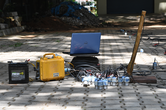
Geophysical and Geotechnical Testing Facilities
Geophysical and Geotechnical Testing Facilities established by Prof. Dr. P. Anbazhagan at Indian Institute of Science (IISc), Bengaluru is a pioneer in geophysical research facilities in India and has actively participated in the work related ground characterization, rock depth mapping, seismic exploration and seismic microzonation projects throughout the nation.
GEOPHYSICAL TESTING FACILITIES
GROUND PENETRATING RADAR (GPR) System
Manufacturer: MALÅ Geosystem
Working Principle: GPR is an electromagnetic ground probing method uses high frequency electromagnetic waves in the microwave range (10 MHz - 2.6 GHz). It detects interfaces between subsurface materials with contrasting dielectric constants. The reflected signals carry the information about the speed of travel and attenuation. A series of such reflected pulses is converted into a continuous profile, a record of subsurface conditions, known as a radargram.
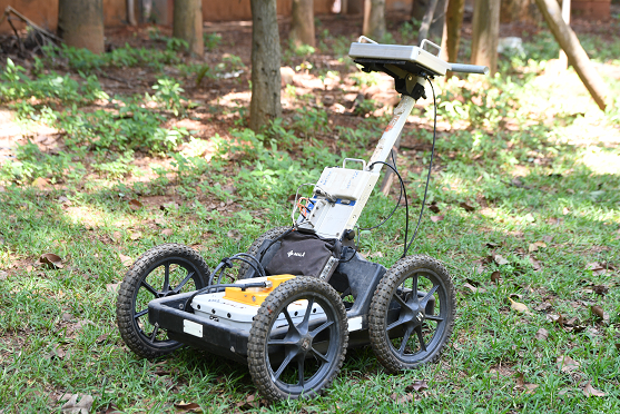
GPR survey results in a resolution of centimeters, which the highest in subsurface imaging of any geophysical method. Antennas available in IISc can deduct smaller object as pen size and lager object as more than 20 m size. The penetration depth ranges from 0.25 m to 50 m.
Application:
Several civil engineering applications include:
- Detection of buried objects such as pipelines, tanks and underground structures
- Detection of air or water filled cavities present in subsurface
- Determining the thickness of various subsurface layers
- Locating reinforcement in concrete slabs and bridge decks
- Identifying deterioration of pavements and underground facilities
- Assessment of compaction quality and subsurface heterogeneity
Instrumentation:
- Control Unit: The MALÅ ProEx and GX are modular digital radar control units with multi-channel functionality. It has a sampling frequency of 2 to >400 GHz and a pulse repetition frequency of 100, 200 kHz. It operates in the temperature range of -20o to 50o C.
- Transmitter Antenna:
- Unshielded antenna
- 25 MHz: Suitable for investigations requiring deep penetrations, geological and stratigraphic survey in open terrain.
- 400 MHz separable: Separate receiver and transmitter system
- Shielded antenna:
- 80 MHz: Low resolution investigations at greater depth of penetration
- 100 MHz: For medium to low resolution investigations for geological and geotechnical applications
- 250 MHz: For shallow to medium depth investigations
- 500 MHz: For shallow to medium depth investigations, as in utility detection and pavement survey.
- 800 MHz: For shallow depth detection, such as road survey and structural investigation in concrete.
- High frequency antenna:
- 1.6 GHz: For high quality radar measurements, with medium penetration. Also capable of detecting radiating 50/60 Hz fields from power cables and/ or other metallic conductors within the structure under investigation.
- Receiver Antenna
- Processing, display and storage unit
- Software: 2D and 3D ReflexW
- Rough Terrain cart: Operational capabilities in rough terrain can be improved by using the MALÅ Rough Terrain Cart (RTC), which can contain all the instrumentation.
Major Projects
| S.No. | Project Title |
|---|---|
| 1 | Seismic Site Classification for Indian Shallow Soil Deposits |
| 2 | Characterization of Rail Track Ballast using Ground Penetrating Radar and Field Sampling |
| 3 | Structural Assessment of Existing Road Pavement Using Field and Laboratory Experiments |
| 4 | Locating buried archaeological features using Ground Penetration Radar |
| 5 | Detection of soil heterogeneity using Ground Penetration Radar |
| 6 | Proof of concept using GPR in Secunderabad Railway Bridge |
| 7 | GPR and MASW Survey for the Study of distorted RE WALL at Anantpur, Andhra Pradesh |
| 8 | GPR study on roads constructed using RBI Grade 81 materials |
| 9 | Mapping of Foundation and Rock depth using GPR at Krishna Temple, Hampi |
| 10 | Ground Penetration Radar (GPR) study to detect Cavities and Weak soil layers |
| 11 | GPR study on railway track to map Ballast Penetration Depth |
| 12 | GPR study on new and old roads |
| 13 | GPR study at Kannur International Airport Project (KIAL)- Runway Section 1-5 |
| 14 | GPR study at Kannur International Airport Project (KIAL)- Parallel Taxiway Section 1 to 5 |
Seismic Surface wave testing- MULTICHANNEL ANALYSIS OF SURFACE WAVES (MASW)
Manufacturer: Geometrics
Working Principle
MASW is a popular seismic exploration technique that evaluates ground stiffness by measuring shear wave velocity by analyzing Raleigh-type surface waves on a multichannel record. The MASW uses the inversion of dispersion curve of surface waves to estimate the variation of the Shear wave velocity (Vs) in a layered medium.
Equipment can be used for Active survey (up to depth of 50 m) and Passive survey MASW for exploration of up to 500 m depth.
The method uses three standard procedures:
- Acquisition of raw experimental data
- Processing of data to obtain experimental dispersion curve.
- Solving the inverse problem to estimate the model parameters- shear wave velocity.
Application:
MASW applications can be grouped into following categories:
- Shear wave velocity for site response and amplification studies
- Soil-Bedrock Mapping
- Seismic Site Characterization
- Anomaly Detection
- Compaction Evaluation
- Grouting Evaluation
Instrumentation:
The test setup at our lab consists of:
- A 24-channel geode seismograph
- 24 vertical Lasco geophones of 2 Hz frequency
- A sledge hammer of 10 kg weight
- "2" thick ms plate of 30 cm x 30 cm
- Two windows based software for processing
- 'Surfseis 5'
- 'ParkSEIS 2'
Major Projects
| S.No. | Project Title |
|---|---|
| 1 | Seismic Hazard Analysis Considering Regional Uncertainties (2016-2019) |
| 2 | Measurement of shear wave velocity at deep soil sites and site response studies (2015-2018) |
| 3 | Seismic Site Classification for Indian Shallow Soil Deposits (2012-2015) |
| 4 | Site Response Studies Using Strong Motion Accelerographs- MoES (2008-2011) |
| 5 | Site Characterization of Indo-Gangetic plains with Studies of Site Response and Liquefaction Hazards -MoEs (2009 -2012) |
| 6 | MASW survey for Measurement of Dynamic Properties at Trinetra Project Site, Najaf garh, New Delhi |
| 7 | Assessment of Seismic Safety of Thippagondanahalli Dam Structure using in-situ measurement of soil and rock properties |
| 8 | GPR and MASW Survey for the Study of distorted RE WALL at Anantpur, Andhra Pradesh |
| 9 | Shear wave velocity measurement using MASW system at south western railway project site |
| 10 | Subsurface Investigation by 2-D Multi Channel Analysis of Surface Wave Testing |
| 11 | Subsurface Investigation by 2-D Multi Channel Analysis of Surface Wave Testing at IGCAR Line 1-1 |
| 12 | Subsurface Investigation by 2-D Multi Channel Analysis of Surface Wave Testing at IGCAR at IGCAR Line 2-2 and 3-3 |
| 13 | Subsurface Investigation by 1-D Multi Channel Analysis of Surface Wave Testing to Measure Shear Wave Velocity up to 500 m at GHAVP site for NPCIL |
| 14 | Subsurface Investigation by 2-D Multi Channel Analysis of Surface Wave Testing to find sub surface at GHAVP site for NPCIL |
| 15 | Generation of subsurface profile with shear wave velocities measurement by passive and active MASW survey at selected locations in Indo-Gangetic Basin. |
| 16 | Mapping of bedrock using integrated geophysical testing of Multichannel Analysis of Surface Wave and Ground Penetrating Radar |
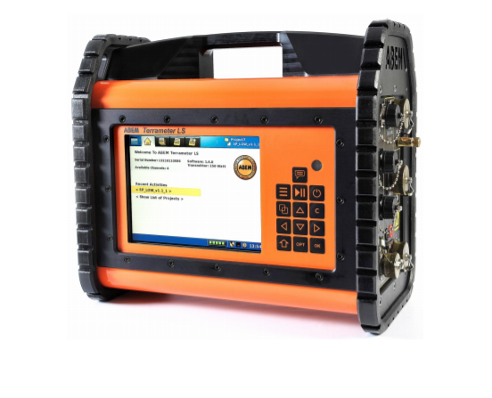
Geo-electrical Resistivity Imaging
ABEM TERRAMETER LS RESISTIVITY METER
Manufacturer: ABEM
Working Principle:
Resistivity/IP (Induced Polarization) is a geo-electrical method that can measure the ground’s resistivity and chargeability properties. Induced polarization (IP) is the Earth's capacity to hold an electric charge over time. IP survey can be carried out in two modes:
- Time domain: Voltage decay is observed as a function of time after the injected current is switched off.
- Frequency domain: An alternating current is injected into the ground with variable frequencies. Voltage phase-shifts are measured to evaluate impedance spectrum at different injection frequencies, which is commonly referred to as spectral IP.
Application:
- Groundwater prospecting
- Mineral exploration
- Geological mapping
- Geothermal prospecting
- Geotechnical investigations.
Instrumentation:
Electrode sensor: The equipment offers up to 12 measurement channels for greater efficiency and productivity in the field. The built-in electrode selector allows for connection of up to 81 electrodes, providing high resolution and impressive depth capabilities. With the use of external electrode selectors over 16 000 electrodes can be connected. It has a full coverage roll along in both 2D and 3D with 100% duty cycle allowing quick data collection. Besides, millions of data recordings can be captured with the 16 GB micro SD memory card.
- Electrodes: Over 100 electrodes are available with the lab.
- Receiver: 24 channels with precision of 0.1% and accuracy of 0.2%. A resolution of 3nV at 1 sec integration can be achieved.
- Transmitter: Constant current transmitter with a maximum output of 2500 mA. The precision and accuracy are 0.1% and 0.2% respectively.
- Others: GPS with GLONASS, 3G and Wi-Fi connectivity, remote connectivity for support and troubleshooting.
SEISMOMETERs/ VELOCITY SENSORS
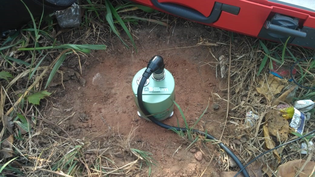
Trilium Compact 120 S Seismometer
Manufacturer: Nanometrics
Working Principle:
These low-noise broadband seismometers are three-component seismometers capable of sensing ground motions over a wide range of frequencies. They work on force balance feedback mechanism with capacitive transducer.
Application:
These sensors are most often used in passive experiments:
- Recording weak motions from
- Regional earthquake
- Teleseismic earthquakes
- Ambient noise.
- H/V ratio survey
Instrumentation:
- Seismometer: The instrument features sensor design with a response flat to velocity from 120 seconds to 100 Hz, bandwidth of -3 dB points at 120s and 108 Hz; and a tilt tolerance of +2.5o. Besides, the instrument offers high station reliability with ultra-low power consumption (180mW), ease of deployment through no mass lock and no mass centering. The instrument is insensitive to natural variations of the earth’s magnetic field. The unit comes with an isolation chamber which should cover the setup when in operation.
- Centaur Digitizer: The Centaur digital recorder is a portable seismic acquisition system that consists of a high-resolution 24-bit ADC, a precision GPS clock, and removable storage capabilities. The Centaur is available in both 3- or 6-channel versions, as well as with a high-gain option. The integrated web server allows constant monitoring of data and efficient instrument management through LAN cable or over Wi-Fi. Multiple seismometers can be connected so that a series of data can be obtained for different points.
This seismometer operates in the temperature range of -20oC to 60oC and is insensitive to natural variations of earth’s magnetic field. It is housed in a single case and is light enough to be used in portable applications.
Major Projects
| S.No | Project Title |
|---|---|
| 1 | Effect of Shear Wave Velocity Calibration on Amplification of Shallow and Deep Soil Sites- M/s. SECON Private Limited, Bangalore |
| 2 | Seismic Hazard Assessment for the proposed Fast Breeder Reactor at BHAVINI, Kalpakkam |
| 3 | Site visit for observation of damages due to vibration and plan vibration measurement and design ground vibration isolation |
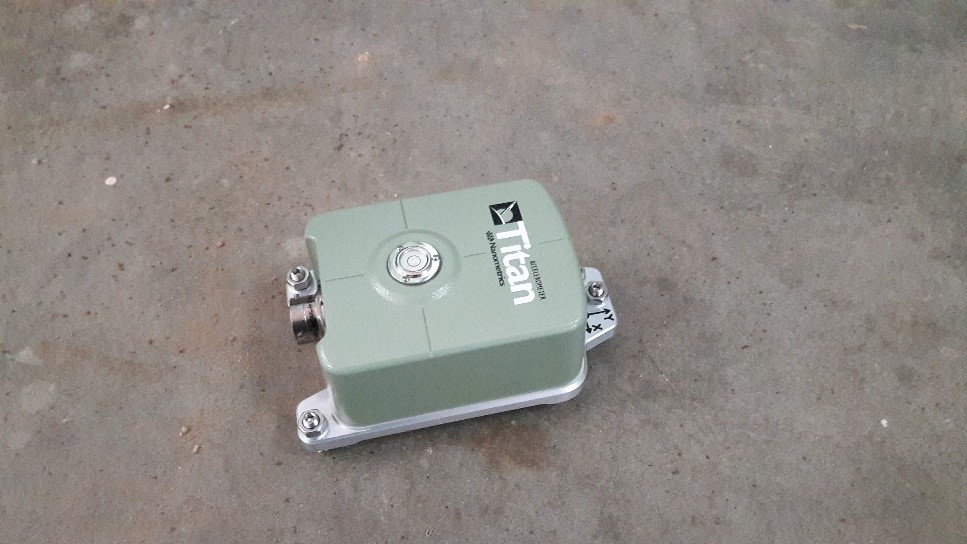
xTitan Accelerometer
Manufacturer: Nanometrics
Working Principle:
Titan accelerometer functions on force balance with a dynamic range of 166 dB over a wide frequency range from DC to 430 Hz (-3 dB point). It offers ultra-low noise seismic performance.
Application:
Accelerometers find use in the following tasks:
- Earthquake Early Warning systems
- Structural Health Monitoring (e.g. dams, industry, buildings)
- Surface and vault installation
- Posthole deployment
- Networked Arrays
Instrumentation:
- Accelerometer: The system incorporates full-scale range of +0.25g to +4g with independent horizontal and vertical range selection and offset zeroing capabilities within +0.005g. The instrument has a dynamic range of 166 dB @ 1 Hz over 1 Hz bandwidth. The instrument works in the operating temperature of -40oC to 70oC.
- Centaur Digitizer: The Centaur digital recorder is a portable seismic acquisition system that consists of a high-resolution 24-bit ADC, a precision GPS clock, and removable storage capabilities. The Centaur is available in both 3- or 6-channel versions, as well as with a high-gain option. The integrated web server allows constant monitoring of data and efficient instrument management through Ethernet cable or over Wi-Fi. Multiple seismometers can be connected so that a series of data can be obtained for different points.
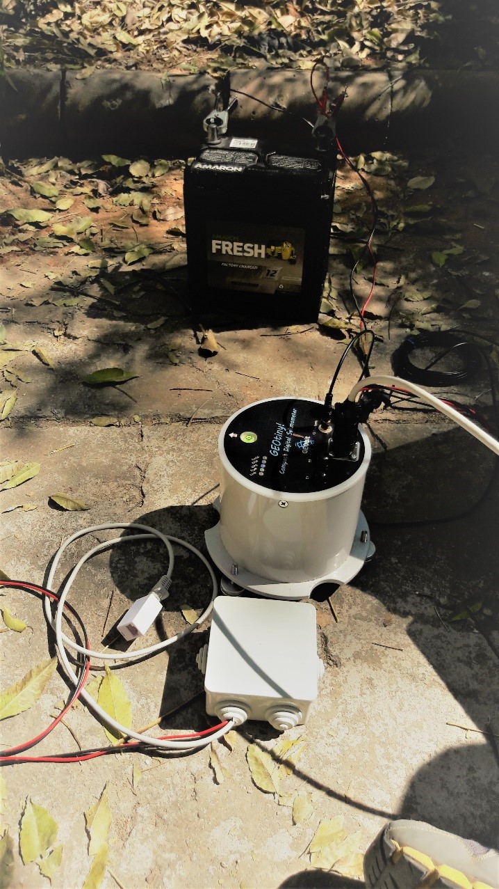
GEOtiny-Digital Seismometer
Manufacturer: GEObit Instruments
Working Principle:
It is a compact miniature digital seismometer that integrates three seismic and three acceleration channels. Modular sensor interface allows the user to select between a variety of sensor types and frequency corners (10sec, 5sec, 2sec, 1sec, 2Hz, 4.5Hz), thus covering the short period and wide band seismic range.
Application:
The sensor finds its applications in
- Aftershock monitoring
- Regional Seismicity Monitoring
- Seismic Tomography Acquisition
- Induced Seismicity Monitoring
- Volcano Monitoring
- Structural Monitoring
- HVSR, MASW surveys
Instrumentation:
The equipment has a 12 channels GPS receiver and runs on 12V battery. It has a sampling rate of 100 samples per second. Working on force-balance technology, it can support a bandwidth of 10s to 120Hz. The instrument has a tilt tolerance of +100 and works in a temperature range of -20 to +700C.
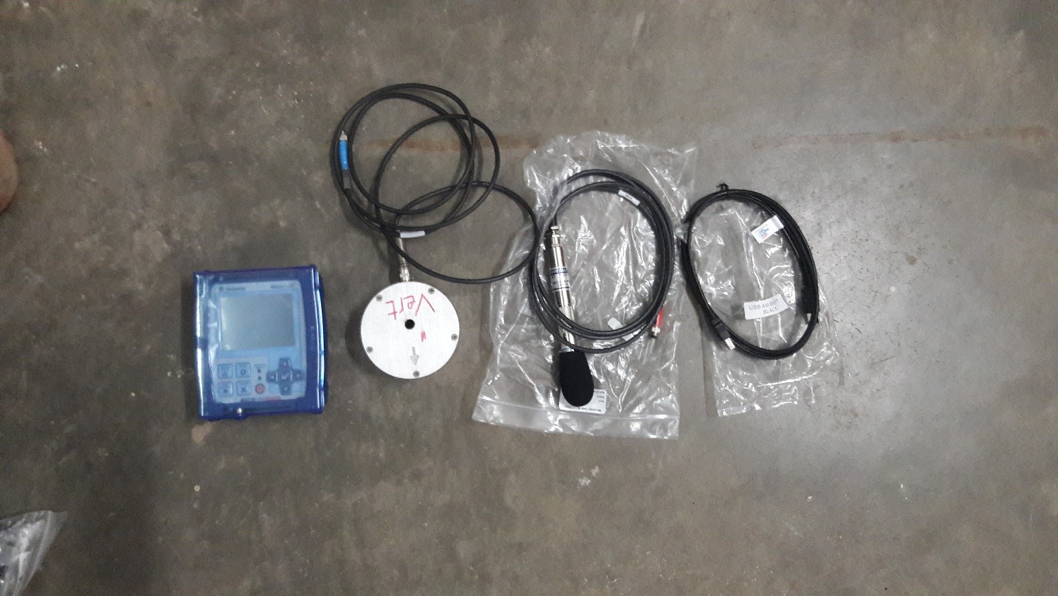
MICROMATE BLAST MONITORING EQUIPMENT
Manufacturer: Instantel
Working Principle:
As the explosives detonate, they create a rapid pressure change that creates vibration waves that travel through the ground and compression waves that travel through the air away from the blast. The effect of the vibrations and airwaves can be felt miles away. By measuring the velocity of the vibrations induced by the blast, we can calculate the time and the distance of blast site. Since vibrations diminish as they travel farther away from the blast, we need a geophone that can record vibrations in close proximity to the blast.
Application:
- Blast monitoring for compliance<
- Near field monitoring
- Sound monitoring
- Pile driving
- Dynamic compaction monitoring
- Demolition activity
- Heavy transportation
- Environmental monitoring
- Tunnel and subway monitoring
- Bridge monitoring
- Structural monitoring and analysis
- Remote access monitoring
Instrumentation:
- Micromate: Monitoring unit three channels for recording vibration on three planes and one channel for air overpressure or noise data. It records up to 65,536 samples per second.
- Triaxial Geophone: High Frequency Geophone records ground vibration in three planes: transverse, vertical and longitudinal and can measure all necessary frequency vibrations from 30 Hz to 1000 Hz.
- Linear Microphone: Records air overpressure data on a linear scale from 2 to 250 Hz with a range of 100 to 148 dB(L) (2 to 500 Pa)
- Sound Level Microphone: Class 1 Sound Level Microphone records noise (or sound) levels.
Major Projects
| S.No. | Project Title |
|---|---|
| 1 | Effect of Shear Wave Velocity Calibration on Amplification of Shallow and Deep Soil Sites- M/s. SECON Private Limited, Bangalore |
| 2 | Noise monitoring of Commercial Buildings |
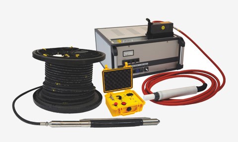
CROSS-HOLE, UP-HOLE AND DOWN-HOLE SEISMIC TESTING
Manufacturer: Geotomographie
Working Principle:
- Cross Hole Seismic testing: Cross hole survey measures the velocity of seismic waves between boreholes. The approach involves lowering a 3-component borehole geophone down one hole while lowering a source down an adjacent hole(s), firing the source at some prescribed depth interval. The energy from each shot is measured at a single depth in each receiver hole. The travel times are then converted to velocities by dividing them into the distance between the holes.
- Downhole Seismic testing: This technique measures vertical changes in seismic velocity by placing a source at the top of a borehole and measuring travel-times at multiple intervals in the borehole, usually with a 3-component geophone.
Application:
Common applications include:
- Bridge/dam foundation analysis
- In-situ materials testing
- Soil and rock mechanics
- Earthquake engineering
- Liquefaction analysis
Instrumentation:
- BIS-SH(S-Wave Source): The borehole source BIS-SH generates horizontally polarized shear waves (SH) and compressional waves (P). The seismic signals are highly repeatable with frequency up to 4 Hz. The source works in dry or water filled. Energy released by the impulse generator discharges through a system of coupled coils to generate a mechanical impact to the borehole wall that releases seismic waves.
- Impulse generator: The impulse generator is the high voltage supply to the seismic S-wave source. It provides impulse voltage of 5000 V, impulse energy of 1000 J with a requirement of power supply of 230 V/110 V, and performs single or continuous shot release.
- Geophone array gstreamer: The borehole seismic array with three-component clamping geophone modules is designed for multiwave cross hole seismic testing.
- Inclinometer probe INCLIS DH: It allows to perform a 3D borehole deviation survey; it is equipped with 3 magnetometric and 3 accelerometric sensors.
Major Projects
| S.No. | Project Title |
|---|---|
| 1 | Effect of Shear Wave Velocity Calibration on Amplification of Shallow and Deep Soil Sites- M/s. SECON Private Limited, Bangalore |
GEOTECHNICAL TESTING FACILITIES
STANDARD PENETRATION TEST HAMMER ENERGY MEASURING APPARATUS (SPT HEMA)
Download SPT- HEMA BrochureManufacturer: Syscon instruments
Working Principle:
A simple and cost-effective SPT-Hammer Energy Measuring Apparatus (HEMA) was developed by the Department of Civil Engineering, IISc, Bangalore. SPT-HEMA is capable of recording energy at below the anvil and above the split spoon sampler tube.
Application:
The SPT-HEMA is a widely used soil exploration tool
- To obtain the N value pertaining to soil strength
- To measure the energy transferred by SPT hammers.
Instrumentation:
- Two instrument rods fitted with an accelerometer and foil type strain gauges for measurement of acceleration and related forces during the test. A microcontroller that filters, amplifies the signals, and processes them via analog-to-digital convertor receives these signals. These instrument rods are placed just below the anvil and just above the sampler.
- Signal conditioners
- Power supply
- SBC
- High Speed DAQ: 16 Bit, 250 K/s aggregate
- Software platform: The software uses Force-Velocity (FV) Method to integrate the product of force and velocity with respect to time as prescribed in ASTM D4633 to give final energy output.
Major Projects Undertaken:
| S.No. | Project Title |
|---|---|
| 1 | Measurement of shear wave velocity at deep soil sites and site response studies |
| 2 | Development of correction factors for SPT N values in India through energy measurement and field experiments—Step towards a reliable Liquefaction Potential Assessment |
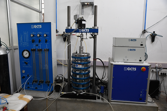
GCTS TSH-100 RESONANT COLUMN/TORSIONAL SHEAR TESTING SYSTEM
Manufacturer: GCTS Testing Systems
Working Principle:
The GCTS TSH-100 Resonant Column/Torsional Shear Testing system combines the features of both resonant column and torsional shear devices into one system so that the effects of soil parameters such as void ratio, confining pressure, strain amplitude, and number of load cycles on shear modulus and material damping can be evaluated. This way, by utilizing all available options, this system is capable of the full spectrum of modulus measurement, ranging from ultra-low strains to high strains with significant overlap.
Application:
The testing setup very conveniently finds the following parameters:
- Resonant frequency
- Maximum shear strain
- Shear velocity
- Shear modulus
- Damping ratio – Free vibration decay
- Damping Ratio – Half Power Bandwidth
- Predominant Frequency from Free Vibration Data FFT Analysis
- Natural Frequency - from Resonant Frequency and Phase Shift
- Natural Frequency - from Resonant Frequency and Free Vibration Decay
- Natural Frequency - from FFT Frequency and Free Vibration Decay
Instrumentation:
- Closed-loop digital control of shear torque or angular deformation with floating torsional drive and measurement system to allow for large vertical specimen deformations at strain levels from 10% to 10-4%. It allows for application of axial loads for anisotropic consolidation or triaxial testing.
- Four-column stainless steel construction with 1000 kPa lateral confining pressure capacity. It accepts samples with diameters from 35 mm to 70 mm and with a length of 2.0 to 2.5 times the diameter.
- Electrical servo motor actuator for the application of torsional loads with 2.33 N-m (peak) and 0.78 N-m (continuous) capacity and up to 250 Hz frequencies.
- Test Specimen Accessories for 70 mm Diameter Solid Specimens Set of test specimen accessories for TSH-100 and end platens with bottom pore water pressure port including the following:
- Top/Bottom end platens
- O-rings for sealing membranes to platens
- Anodize aluminum calibration specimen.
- Fiber Optics Deformation Sensor with Dual Range Output. +/- 0.1 mm low range and +/-6.0 mm high range with 0-15 kHz flat frequency response.
- Deformation sensor with ±6 mm with 0.25% linearity.
- Microprocessor based digital servo controller, function generator, data acquisition, and digital I/O unit.
- 32-bit Windows 98/2000/NT/XP software for advanced digital servo control.
- Resonant Column test module to automatically perform conventional resonant column tests.
Major Projects
| S No. | Project |
|---|---|
| 1 | Development of shear modulus and damping curves and liquefaction analysis of soil samples by carrying out dynamic and static tests |
P AND S WAVE EQUIPMENT WITH AUTOMATED TRIAXIAL TESTING FACILITIES
Manufacturer: VJTech
Working Principle:
The maximum shear modulus (G0) or very small strain stiffness is widely recognized as a reference parameter for the definition of constitutive properties of soils. It can be determined in the laboratory in dynamic tests, by measuring shear wave velocities. The seismic wave velocities can be very conveniently found using Bender elements.
Cyclic triaxial test is a laboratory testing method used to determine the cyclic strength (sometimes called the liquefaction potential) of saturated soils in either intact or reconstituted states by the load-controlled cyclic triaxial technique. The results are used for evaluating the ability of a soil to resist the shear stresses induced in a soil mass due to earthquake or other cyclic loading. Bender elements (BE) are used to generate and measure shear wave velocity in the soil. The advantage of using BE is in its simplicity and ease.
Application:
The setup accounts for following applications:
- To determine dynamic properties at high strain levels.
- To measure seismic wave velocity in the soil
Instrumentation:
The setup consists of general triaxial testing components, accompanied by Advanced automated loading frame and Bender Element test equipment.
- Advanced load frame: They have a load capacity of 50 kN with a speed range of 0 - 50.80000 mm/min. It is controlled with Automatic Pressure Controllers for fully automatic Triaxial testing. It can accept Triaxial cells of 35 mm (1.38"), 38 mm (1.5"), 50 mm (2"), 75 mm (3") and 100 mm (4").
- Triaxial cell: Triaxial cell for Bender Elements & On-sample Transducers is made specifically for Bender and/or On-Sample triaxial testing. It is capable of withstanding confining pressures up to 2000 kPa (290 psi) and is designed with specially coated material to minimise corrosion. Two exit holes are provided to perform Bender Element test. With all exit holes sealed, it can be used for standard Triaxial testing.
- Bender element interface unit: Oscilloscope specifically designed for Bender tests with two channels for Vertical and Horizontal S and P-Waves. It can generate vertical and horizontal P and S waves, in sinusoidal and triangular waveforms. It can conveniently define intervals between pulses during single or multiple pulse generation.
- Top cap and base pedestal: They are made of lightweight alloy with hard-anodized coating to minimize corrosion and provision for drain tube.
- Bender Elements: The Bender elements are encapsulated in titanium and set into the Top Cap and Base Pedestal. The cable from the top cap has an adjustable cable adaptor for exit through the cell base and both cables are fitted with LEMO plugs.
INTEGRATED SUBSURFACE INVESTIGATION USING GEOPHYSICAL AND GEOTECHNICAL TESTING
The effective planning and execution of civil construction project requires integrated subsurface investigation, so that project can be completed in time. Integrated subsurface investigation is not only useful for new project construction but also helps in forensic investigation of the geotechnical failure for effective retrofitting and restoration.
Many geophysical methods are engaged in the forensic investigation of geotechnical failures. Introducing an innovative and unconventional approach in the deep soil deposits of Indo-Gangetic Basin, seismic method of MASW, electromagnetic method of GPR, and limited drilling with SPT N measurement were successfully used to investigate the heterogeneous compaction, undulation subsurface, and karstic features in lateritic soil. Seismic methods were employed to estimate the shear wave velocity of the subsurface layers and thereby Young’s modulus and shear modulus. In the project, GPR was used to identify the subsurface condition of the soil, thickness and homogeneity of the layers. The SPT results were later utilized to get subsurface material type and depth, to compare with MASW result and to get in situ density.
Related List of Publications:
Journal Publications:
- Panjamani, Anbazhagan & Rohit, Divyesh & Prabhakaran, Athul & Bandi, Vidyaranya. (2018). Identification of Karstic Features in Lateritic Soil by an Integrated Geophysical Approach. Pure and Applied Geophysics. 175. 10.1007/s00024-018-1908-8.
- Chandran, Deepu & Panjamani, Anbazhagan. (2017). Subsurface profiling using integrated geophysical methods for 2D site response analysis in Bangalore city, India: A new approach. Journal of Geophysics and Engineering. 14. 10.1088/1742-2140/aa7bc4.
- Panjamani, Anbazhagan & Uday, Anjali & Moustafa, Sayed & Alarifi, Nassir. (2017). Soil void ratio correlation with shear wave velocities and SPT N values for Indo-Gangetic basin. Journal of the Geological Society of India. 89. 398-406. 10.1007/s12594-017-0621-z.
- Panjamani, Anbazhagan & Bajaj, Ketan & Dutta, Nairwita & Moustafa, Sayed & Alarifi, Nassir. (2017). Region-specific deterministic and probabilistic seismic hazard analysis of Kanpur city. Journal of Earth System Science. 126. 10.1007/s12040-016-0779-6.
- Panjamani, Anbazhagan & Uday, Anjali & Moustafa, Sayed & Alarifi, Nassir. (2016). Correlation of densities with shear wave velocities and SPT N values. Journal of Geophysics and Engineering. 13. 320-341. 10.1088/1742-2132/13/3/320.
- Panjamani, Anbazhagan & Bajaj, Ketan & R. Reddy, G & Phanikanth, V & N. Yadav, D. (2016). Quantitative Assessment of Shear Wave Velocity Correlations in the Shallow Bedrock Sites. Indian Geotechnical Journal. 46. 10.1007/s40098-016-0181-y.
- Panjamani, Anbazhagan & Bajaj, Ketan & R. Reddy, G & Phanikanth, V & N. Yadav, D. (2016). Quantitative Assessment of Shear Wave Velocity Correlations in the Shallow Bedrock Sites. Indian Geotechnical Journal. 46. 10.1007/s40098-016-0181-y.
- Panjamani, Anbazhagan & L SivakumarBabu, G & P, Lakshmikanthan & S VivekAnand, K. (2016). Seismic characterization and dynamic site response of a municipal solid waste landfill in Bangalore, India. Waste management & research : the journal of the International Solid Wastes and Public Cleansing Association, ISWA. 34. 10.1177/0734242X15622814.
- Ravindran, Antony & C. Mondal, N & Nr, Ramanujam & Krishnaraj, Srinivasamoorthy & Panjamani, Anbazhagan. (2016). Appraisal of groundwater resource in Holocene soil deposits by resistivity, hydrochemical and granulomerial studies in the Gulf of Mannar Coast from Southern India. Environmental Earth Sciences. 75. 166.
- Panjamani, Anbazhagan. (2015). Integrated Subsurface Investigation of the Misaligned Reinforced Soil Retaining Wall. Indian Geotechnical Journal. 45. 332–340. 10.1007/s40098-014-0135-1.
- Kumar, Abhishek & Panjamani, Anbazhagan & Thallak, Sitharam. (2013). Liquefaction Hazard Mapping of Lucknow: A Part of Indo-Gangetic Basin (IGB). International Journal of Geotechnical Earthquake Engineering. 4(1). 17-41. 10.4018/jgee.2013010102.
- Kumar, Abhishek & Panjamani, Anbazhagan & Thallak, Sitharam. (2012). Site Specific Ground Response Study of Deep Indo-Gangetic Basin Using Representative Regional Ground Motions. Americal Society of Civil Engineers. 10.1061/9780784412121.194.
- Panjamani, Anbazhagan & Kumar, Abhishek & Thallak, Sitharam. (2012). Seismic Site Classification and Correlation between Standard Penetration Test N Value and Shear Wave Velocity for Lucknow City in Indo-Gangetic Basin. Pure and Applied Geophysics. 170. 10.1007/s00024-012-0525-1.
- Panjamani, Anbazhagan & Parihar, Aditya & Rashmi, H.N.. (2011). Amplification based on shear wave velocity for seismic zonation: Comparison of empirical relations and site response results for shallow engineering bedrock sites. Geomechanics and Geoengineering. 3. 189-206. 10.12989/gae.2011.3.3.189.
- Panjamani, Anbazhagan & Indraratna, B & G, Amarajeevi. (2011). Characterization of Clean and Fouled Rail Track Ballast and Subsurface using Seismic Surface Survey Method: Model and Field Studies. ASTM Journal of Testing and Evaluation. 39. 831-841. 10.1520/JTE103472.
- Panjamani, Anbazhagan & Thingbaijam, KKS & Nath, Sankar & N. Narendara Kumar, J & Thallak, Sitharam. (2010). Multi-criteria seismic hazard evaluation for Bangalore city, India. Journal of Asian Earth Sciences. 38. 186-198. 10.1016/j.jseaes.2010.01.001.
- Panjamani, Anbazhagan & Thallak, Sitharam. (2010). Relationship between Low Strain Shear Modulus and Standard Penetration Test 'N' Values. ASTM Geotechnical Testing Journal. 33. 150-164. 10.1520/GTJ102278.
- Panjamani, Anbazhagan & Thallak, Sitharam. (2009). Seismic microzonation of Bangalore, India. Journal of Earth System Science. 117. 833-852. 10.1007/s12040-008-0071-5.
- Panjamani, Anbazhagan & Thallak, Sitharam & K S, Vipin. (2009). Site classification and estimation of surface level seismic hazard using geophysical data and probabilistic approach. Journal of Applied Geophysics. 68. 219-230. 10.1016/j.jappgeo.2008.11.001.
- Panjamani, Anbazhagan. (2009). Liquefaction Hazard Mapping of Bangalore, South India. Disaster Advances. 2. 26-35.
- Panjamani, Anbazhagan & Thallak, Sitharam. (2009). Spatial Variability of the Depth of Weathered and Engineering Bedrock using Multichannel Analysis of Surface Wave Method. Pure and Applied Geophysics. 166. 409-428. 10.1007/s00024-009-0450-0.
- Panjamani, Anbazhagan & Thallak, Sitharam. (2009). Estimation of Ground Response Parameters and Comparison with Field Measurements. Indian Geotechnical Journal. 39. 245-270.
- Panjamani, Anbazhagan & Thallak, Sitharam. (2008). Mapping of Average Shear Wave Velocity for Bangalore Region: A Case Study. Journal of Environmental and Engineering Geophysics - J ENVIRON ENG GEOPHYS. 13. 69-84. 10.2113/JEEG13.2.69.
- Panjamani, Anbazhagan & Thallak, Sitharam. (2008). Evaluation of Low Strain Dynamic Properties using Geophysical Method: A Case Study. Consulting Ahead. 2. 34-50.
- Thallak, Sitharam & Panjamani, Anbazhagan. (2008). Seismic Microzonation: Principles, Practices and Experiments.
- Panjamani, Anbazhagan & Thallak, Sitharam. (2008). Site Characterization and Site Response Studies Using Shear Wave Velocity. Journal of Seismology and Earthquake Engineering. 10. 53-67.
- Thallak, Sitharam & Panjamani, Anbazhagan & Mahesh, Dr Upender. (2007). 3-D subsurface modeling and preliminary liquefaction hazard mapping of Bangalore city using SPT data and GIS. Indian Geotechnical Journal. 37. 210-226.
- Panjamani, Anbazhagan & Thallak, Sitharam & Babu, G. (2007). Evaluation of dynamic properties of site and Response of Motion Simulator Foundation.
- Thallak, Sitharam & Panjamani, Anbazhagan. (2006). Measurements of Dynamic Properties and Soil Profiling Using Multichannel Analysis of Surface Waves.
- Panjamani, Anbazhagan & Thallak, Sitharam. (2006). Evaluation of Dynamic Properties and Ground Profiles Using Masw: Correlation Between Vs And N60.
Conference Publications:
- Bajaj, Ketan & Panjamani, Anbazhagan. (2017). COMBINED ACTIVE AND PASSIVE MULTI-CHANNEL ANALYSIS OF SURFACE WAVES FOR SITE CHARACTERIZATION OF INDO-GANGETIC BASIN, INDIA. 365-365. 10.4133/SAGEEP.30-045.
- Panjamani, Anbazhagan & Agrawal, Ayush & Prakash, D. (2016). EFFECT OF ENERGY EFFICIENCY OF HAMMER ON LIQUEFACTION POTENTIAL OF SOIL.
- Panjamani, Anbazhagan & Manohar, D R. (2016). Small- to Large-Strain Shear Modulus and Damping Ratio of Sand-Tyre Crumb Mixtures. 305-315. 10.1061/9780784480151.031.
- Panjamani, Anbazhagan & Prabhakaran, Athul & Bajaj, Ketan. (2016). Site Specific Seismic Hazard Assessment of the TG Halli Dam.
- Panjamani, Anbazhagan & Rohit, Divyesh & Prabhakaran, Athul. (2016). Investigations of Existing Dam using Integrated Geotechnical and Geophysical Methods.
- Chandran, Deepu & Quan, Yuan & Panjamani, Anbazhagan & Kadar Prabhu, Abdul. (2014). INTEGRATED SITE INVESTIGATION OF SHALLOW BEDROCK SITES FOR SEISMIC SITE RESPONSE STUDY.
- Panjamani, Anbazhagan & Chandran, Deepu & Burman, Shashank. (2014). Subsurface Imaging and Interpretation using Ground Penetrating Radar (GPR) and Fast Fourier Transformation (FFT). 10.3233/978-1-61499-417-6-254.
- Panjamani, Anbazhagan & Parihar, Aditya & Kumar, Abhishek. (2014). Indian Seismic Microzonation Practices and Research Challenges.
- Panjamani, Anbazhagan. (2014). Methodology for Seismic Microzonation - Case study of Bangalore.
- Panjamani, Anbazhagan & Selvam L, Panneer & , Sreenivas & H K, Akshath & , Peter. (2013). Indigenous SPT -Hammer Energy Measurement Apparatus and Preliminary Studies.
- Dixit P S, Naresh & Chandran, Deepu & Murali Krishna, A & Panjamani, Anbazhagan. (2013). Investigation of Soil Saturation and Compaction Homogeneity in the failed soil nailed wall and fill using Ground Penetrating Radar. 10.13140/RG.2.1.1820.5605.
- Panjamani, Anbazhagan & Dutta, Nairwita & Bajaj, Ketan. (2013). Seismic Hazard Analysis, Site Classification and Site Response - Practice, Problems and Prospect.
- Panjamani, Anbazhagan & M, Sreenivas & C S, Anusha. (2012). Geotechnical and Geophysical Testing for Seismic Re-Qualification of Geotechnical Structures.
- Panjamani, Anbazhagan & Chandran, Deepu & Burman, Shashank. (2012). Investigation of Soil Compaction Homogeneity in a Finished Building Using Ground Penetrating Radar. Forensic Engineering 2012: Gateway to a Better Tomorrow - Proceedings of the 6th Congress on Forensic Engineering. 773-782. 10.1061/9780784412640.082. .
- Panjamani, Anbazhagan & N. Rashmi, H. (2011). Characterization of Rail Track Subsurface Using Seismic Refraction Survey. 57-65. 10.1061/47626(405)8.
- Chandran, Deepu & Panjamani, Anbazhagan & , Kumar.V. (2011). Pavement Thickness and Stiffness Evaluation using Ground Penetrating Radar and Surface Wave Method.
- Chandran, Deepu & Panjamani, Anbazhagan & , Kumar.V. (2011). Thickness Evaluation for Flexible pavement Using Ground Penetrating Radar.
- Kumar, Abhishek & Panjamani, Anbazhagan & Thallak, Sitharam. (2011). Evaluation of site classification for soils in Lucknow urban centre and Correlation between SPT-N value and Vs, S9_C6.
- Panjamani, Anbazhagan & Chandran, Deepu & Parihar, Aditya & Rajkumar Singh, M. (2011). Subsurface Characterization Using Seismic and Ground Penetrating Radar – Compare with In-Situ Sampling.
- Kumar, Abhishek & Panjamani, Anbazhagan & Thallak, Sitharam. (2010). Shear Wave Velocity Profiling for Lucknow Urban centre using Seismic Refraction Survey.
- Panjamani, Anbazhagan & Thallak, Sitharam. (2010). Seismic Site Classification Using Boreholes and Shear Wave Velocity: Assessing the Suitable Method for Shallow Engineering Rock Region. Geotechnical Special Publication. 1059-1068. 10.1061/41095(365)105.
- Panjamani, Anbazhagan & Thallak, Sitharam & C, Divya. (2007). SITE RESPONSE ANALYSES BASED ON SITE SPECIFIC SOIL PROPERTIES USING GEOTECHNICAL AND GEOPHYSICAL TESTS: CORRELATIONS BETWEEN GMAX AND N60.
- Bakku, Sudhish Kumar & Panjamani, Anbazhagan & Thallak, Sitharam. (2006). DEVELOPMENT OF THEORETICAL DISPERSION CURVES AND COMPARISON WITH MULTICHANNEL ANALYSIS OF SURFACE WAVES (MASW).
- Panjamani, Anbazhagan & Raju, Govinda. (2006). SEISMIC RESPONSE OF SOILS A CASE STUDY OF SITE SPECIFIC GROUND RESPONSE ANALYSIS.
To contact
| Phone: | 91-080-22932467 |
| Cell: | 91-9448100410 |
| Fax: | 91-080-23600404 |
| Email: | anbazhagan2005@gmail.com, anbazhagan@iisc.ac.in |