Department of Civil Engineering,Indian Institute of Science, Bangalore
Seismic Hazard
Seismic Hazard Analysis
Seismic hazard analysis involves the quantitative estimation of ground shaking hazards at a particular area. Seismic hazards can be analyzed deterministically as and when a particular earthquake scenario is assumed, or probabilistically, in which uncertainties in earthquake size, location, and time of occurrence are explicitly considered (Kramer, 1996). A critical part of seismic hazard analysis is the determination of Peak Ground Acceleration (PGA) and response acceleration (spectral acceleration) for an area/site. Spectral acceleration (Sa) is preferred for the design of civil engineering structures. It is an accepted trend in engineering practice to develop design response spectrum for different types of foundation materials such as rock, hard soil and weak soils. Analysis of lineaments and faults helps in understanding the regional seismotectonic activity of the area. Lineaments are linear features seen on the surface of earth which represents faults, features, shear zones, joints, litho contacts, dykes, etc; and are of great relevance to geoscientists.
Deterministic Seismic Hazard Analysis (DSHA)
Krinitzsky (2005) highlights that a Deterministic Seismic Hazard Analysis (DSHA) uses geology and seismic history to identify earthquake sources and to interpret the strongest earthquake each source is capable of producing regardless of time, because that earthquake might happen tomorrow. Those are the Maximum Credible Earthquakes (MCEs), the largest earthquakes that can reasonably be expected. As we cannot safely predict when an earthquake will happen, the MCEs are what a critical structure should be designed for if the structure is to avoid surprises. Deterministic seismic hazard assessment is carried out to identify the Maximum Credible Earthquake (MCE) that will affect a site. The MCE is the largest earthquake that appears possible along a recognized fault under the presently known or presumed tectonic activity (USCOLD, 1995), which will cause the most severe consequences to the site. Deterministic Seismic Hazard Analysis (DSHA) for Bangalore has been carried out by considering the past earthquakes, assumed subsurface fault rupture lengths and point source synthetic ground motion model. Maximum Credible Earthquake (MCE) has been determined by considering the regional seismotectonic activity in about 350 km radius around Bangalore. Source magnitude for each source is chosen from the maximum reported past earthquake close to that source and shortest distance from each source to Bangalore is arrived from the newly prepared seismotectonic map. Using these details and regional attenuation relation developed for southern India by Iyengar and Raghukanth (2004), the peak ground acceleration (PGA) has been estimated. To estimate the expected magnitude for seismic source, a parametric study has been carried out to find subsurface rupture length of the fault using past earthquake data and Wells and Coppersmith (1994) relation between the subsurface lengths versus earthquake magnitudes. About more than 60% of earthquake magnitude matches with the subsurface length corresponding to 3.8% of the total length of fault. The expected maximum magnitude for each source has been evaluated by assuming that the seismic source can be ruptured at subsurface level for a length of 3.8% of the total length of source. The PGA for Bangalore has been estimated using expected magnitudes and regional attenuation relation. Further seismological model developed by Boore (1983, 2003), SMSIM program, has been used to generate synthetic ground motions for sources resulting higher PGA in the above two methods 1) using regional attenuation equation and largest earthquake close to source, and, 2) using regional attenuation equation and expected maximum magnitude arrived by assuming subsurface rupture length. The seismic sources (8 numbers) causing considerable PGA value from the method I, and II, are further used for generating the synthetic ground motions.
Synthetic Earthquake Model and Peak ground acceleration map
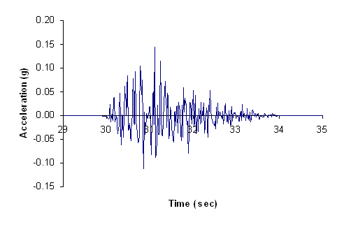
For microzonation, the study of local site effects need to be carried out for a scenario earthquake estimated in the seismic hazard analysis. To study the local site effects of earthquake in the local scale level, the scenario earthquake record/ground motion in the form of time series is required. For the area having limited seismic record, synthetic ground motion models is the alternative (as the study area lacks ground motion records). Modeling of strong motion helps to estimate future hazard of the region and study the local soil effects in local scale. For south India, Iyengar and Raghukanth (2004) have developed ground motion attenuation relation based on the statistically simulated seismological model. Seismological model by Boore (1983) is used for generation of synthetic acceleration-time response (Atkinson and Boore 1995, Hwang and Huo 1997). The synthetic ground motion and spectral acceleration at rock level for 8 seismic sources are developed by considering expected magnitude and hypocentral distance along with the above regional seismic hazard parameters. The PGA values obtained form synthetic ground motion model using regional seismotectonic parameters varies from 0.005g to 0.136g. The lineament L15 gives the highest PGA value of 0.136g by taking hypocentral distance of 15.88km. Further, PGA obtained from the model for the L15 matches well with the PGA values from both the above approaches.
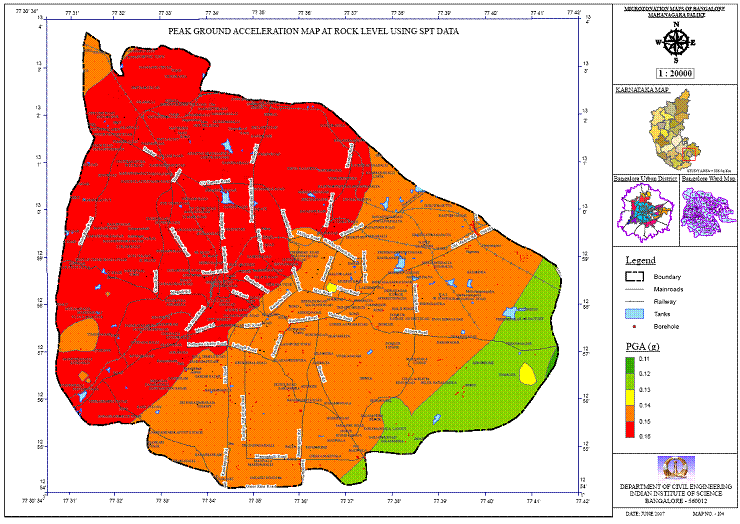
Further rock level PGA is estimated considering the Mandya-Channapatna-Bangalore lineament (L15) as the source and maximum credible earthquake of 5.1 in moment magnitude. Using these PGA values, rock level PGA map has been prepared and is shown in Figure. From the above three approaches maximum PGA of about 0.15g was estimated.
Probabilistic Seismic Hazard Analysis (PSHA)
PSHA is the most commonly used approach to evaluate the seismic design load for the important engineering projects. PSHA method was initially developed by Cornell (1968) and its computer form was developed by McGuire (1976 and 1978) and Algermissen and Perkins (1976). McGuire developed EqRisk in the year 1976 and FRISK in the year 1978. Algermissen and Perkins (1976) developed RISK4a, presently called as SeisRisk III. Site ground motions are estimated for selected values of the probability of ground motion exceedance in a design period of the structures or for selected values of annual frequency or return period for ground motion exceedance. The probabilistic approach offers a rational framework for risk management by taking account of the frequency or probability of exceedance of the ground motion against which a structure or facility is designed. The occurrence of earthquakes in a seismic source is assumed as the Poisson distribution. The probability distribution is defined in terms of the annual rate of exceeding the ground motion level z at the site under consideration (), due to all possible pairs (M, R) of the magnitude and epicentral distance of the earthquake event expected around the site, considering its random nature.
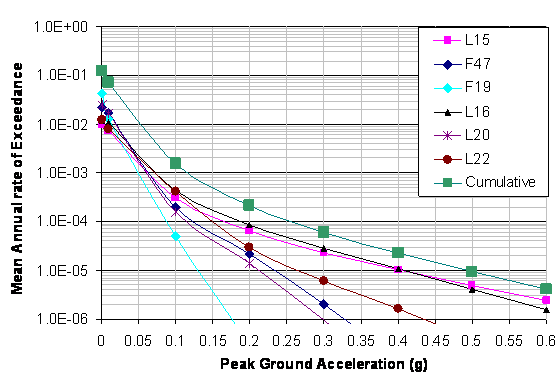
In this study evaluation of seismic parameter b has been carried out using the seismic data over an area having a 350 km radius around Bangalore. Seismic parameter b has been evaluated from (1) G-R relationship (Gutenberg and Richter, 1944) (2) Kijko and Sellevoll (1989, 1992) method utilizing extreme, instrumented and complete catalogs. The Probabilistic seismic hazard analysis for Bangalore region has been carried out by considering six seismogenic sources identified in DSHA studies by Sitharam et.al., 2006; Sitharam and Anbazhagan (2007). The study area is divided by grid size of 0.5 kmx0.5 km, hazard parameters are estimated at center point of each grid using newly developed MATLAB program. The hazard curves of mean annual rate of exceedance versus Peak Ground Acceleration (PGA) and mean annual rate of exceedance versus Spectral Acceleration (Sa) are generated at the rock levels.The quantified hazard in terms of the
rock level peak ground acceleration values are mapped 10% probability of exceedance in 50 years. These values correspond to return periods of nearly 475 years. In addition, Uniform Hazard Response Spectra (UHRS) for Bangalore city at rock level with natural periods of 1 second for 10% probability of exceedance in 50 years of exposure period have also been presented. Further to define the seismic hazard at rock level for the study area, PGA at each grind point has been estimated. These values are used to prepare PGA distribution maps for 10% probability exceedance in 50 years, which corresponds to return periods of 475 years.
Rupture based seismic hazard analysis (RBSHA)
Most of the hazard analyses/zonations are being carried out considering the past earthquake location, size, and rate of occurrence of past earthquakes on the fault or in the region for future design of structures. Moderate to major earthquakes need sufficient energy to rupture the faults. Time required to buildup the required energy to create moderate to major earthquakes is a region-specific. So, interval between two consecutive earthquakes in the same location is considerable, but it is accounted poorly in the hazard analysis and future seismic zonation. Earthquakes relive the strain energy that builds up on faults, next earthquake in the region is more likely to occur in areas where little or no seismic activity has been observed for some time (Kramer 1996). Based on the average return period of earthquakes in the region, one can assess the potential of past earthquake location for generating the future similar earthquakes. Let the place/source having earthquake magnitude of M with an average return period of T has ruptured by an amount of R. Amount of rupture depends on the seismotectonic of the region and seismic sources. Maximum magnitude reported in the region is Mmax and M is the average damaging earthquake in the region. If M and Mmax are relatively comparable, the possibility of occurrence of the same M or Mmax in the same (reported past) location is rare up to period T. Hence, for the future seismic zonation for period less than T, these locations can be eliminated or considered as areas with no potential for occurrence of near-future earthquake. But in the conventional hazard analysis for future zonation of time period less than T, these locations are considered and probable magnitude is arrived by adding 0.3 to 1 more to Mmax. Also, possibility of occurrence of damaging earthquake in other locations/sources is not accounted. In order to account the possibility of occurrence of earthquake in the locations other than past damaging earthquake locations, a new seismic hazard analysis has been attempted in this paper that is named as Rupture Based Seismic Hazard Analysis (RBSHA) for future zonation. Steps for rupture-based seismic hazard analysis with typical case study of Coimbatore city was presented in Anbazhagan et al (2011) . The authors also compared RBSHA results with conventional deterministic seismic hazard analysis and discussed. Panjamani Anbazhagan, Prabhu Gajawada, Aditya Parihar (2011) Seismic hazard map of Coimbatore using subsurface fault rupture, Nat Hazards, Available in online
To contact
| Phone: | +91-080-22932467 |
| Cell: | +91-9448100410 |
| Fax: | +91-080-23600404 |
| Email: | anbazhagan@iisc.ac.in , anbazhagan2005@gmail.com |